geospatial
Minimizing the impact of desert locust swarms in East Africa
September 09 by Maxar Technologies
Spotlight, the monthly geospatial intelligence periodical from Maxar
Methamphetamine in Afghanistan: Assessing Changes to Participation and Production
July 13 by Maxar Technologies
Spotlight, the monthly geospatial intelligence periodical from Maxar
APAC National Security: Why GIS Is More Important Than Ever Before
July 23 by Defence IQ Digital
Transformative new developments in GIS technology have prompted national security organisations across APAC to enhance their GEOINT capabilities. Defence IQ takes a look at the views of leading...
GEOINT: Latest Technologies and Opportunities to Enhance APAC Security
July 23 by Defence IQ Digital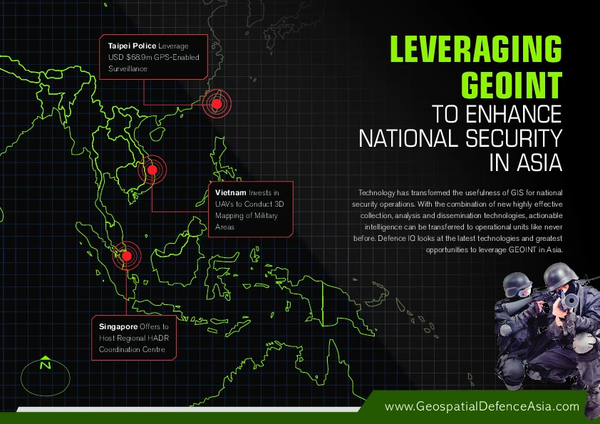
Technology has transformed the usefulness of GIS for national security operations. With the combination of new highly effective collection, analysis and dissemination technologies, actionable in...
Port security going geospatial...but cyber security remains a hurdle
May 13 by Richard de SilvaGeospatial systems are becoming a keenly valued capability for port security measures, wherein security teams have found an advantage in advanced surveillance and tracking of the immediate area. S...
UAE seeks new technology to keep track on criminals
May 10 by Defence IQ PressSome of the world’s foremost intelligence experts are congregating at the 6thAnnual Geospatial Intelligence Middle Eastconference in Abu Dhabi next week from 13 – 15 May 2013 at the West...
Current & Future Trends in Geographic Information Systems in the Middle East
April 11 by Defence IQ Digital
This study was devised in order to capture what the market perceives to be the current and future status of GIS technology and the industry in general within the Middle East region. This report also...
We've only had a "glimpse of the power" of social networks, says NGA official
April 10 by Andrew ElwellDr. Charlette "Cookie" Watkins, a Director at the National Geospatial Intelligence Agency, recently spoke to Defence IQ further to her presentation at the Geospatial Intelligence Middle East confere...
Lockheed Martin UK Wins Ministry of Defence Future Deployable Geospatial Intelligence Project
January 31 by Lockheed Martin Press OfficeFARNBOROUGH, HAMPSHIRE, 30 January, 2012 – The Ministry of Defence (MoD) has awarded Lockheed Martin UK Information Systems & Global Solutions (IS&GS) and its industry team, Team SOCRATE...
Can Mars Save NASA's Dying Human Spaceflight Programme?
May 02 by Lexington InstituteThe greatest adventure in human history is ending in its infancy. NASA's human spaceflight program, a signature achievement of American civilization, is dying. The program was conceived during the b...
USAF and Lockheed Martin deliver first missile warning spacecraft
March 09 by Lockheed Martin Press OfficeThe U.S. Air Force and Lockheed Martin team has delivered the first geosynchronous (GEO-1) Space Based Infrared System (SBIRS) spacecraft to Cape Canaveral Air Force Station, Fla., where it will be...
Geospatial Location Processes in Applied Defence Scenarios: Whitepaper
February 24 by Defence IQ Digital
Every aspect of defence and intelligence decision support involves geographic information. Military decisions depend on digital maps; location coordinates from GPS units on vehicles and war fighters...